Pruitt-Igoe can be a catalyst for redeveloping the near north side of St. Louis in a sensitive manner. Inspired by the beautiful brick neighborhoods that survive in various parts of the city, the design provides a home for people of various incomes, ages, and family sizes.
(To view full size images, Right-Click on each image and select Open Link in New Tab)

This project originated from a desire to explore affordable mixed-income development, mixed-use urban infill, and the relationship between regional vernacular and classical architecture. Purpose-built affordable housing is a sensitive issue, with a history of many unsuccessful developments. This project, therefore, does not attempt to propose overarching solutions to the issues surrounding the housing of the poor, but instead suggests locally specific strategies for development. A design which sensitively gleans lessons from a place will usually be superior to one that imposes its will on its site. With that in mind, the design of this project grows out of an extensive study of the patterns engrained in some of the most diverse and enduring neighborhoods in St. Louis. The project attempts to demonstrate the merits of developing the former Pruitt-Igoe site as a walkable, connected, mixed-use, and mixed-income neighborhood center, composed of traditional St. Louis urban patterns and building types.

The location of the project is a 33-acre brownfield site in the Desoto-Carr neighborhood on the northern edge of St. Louis’ downtown. The site is historically significant as it was a portion of the 57-acre Pruitt-Igoe housing project. Designed by Minoru Yamasaki and completed in 1956, Pruitt-Igoe was initially hailed as a groundbreaking architectural solution to social housing, but quickly became characterized by violence, racial and economic segregation, destruction of property, rampant poverty, and gang activity. Nonetheless, it housed a tight-knit community. For a fascinating and well constructed documentary on Pruitt-Igoe, I recommend The Pruitt-Igoe Myth (2011). It does not cover all of the points made in the 1991 paper of the same name by Katherine Bristol, but is a good overall picture of the Pruitt-Igoe community and notes some of the generally unmentioned reasons that the project failed, such as the suburban expansion of St. Louis.
The project, composed of 33 eleven-story towers surrounded by open grassy areas and parking, exemplified the disastrous state of modern public housing, standing only 16 years (1956 – 1972) before the first of its buildings was demolished. The incredible failure of Pruitt-Igoe had an intense effect on the architectural community, casting a stigma on Modernist architecture and, according to Charles Jencks, signaling its death (Jencks, 1984). While the degeneration of Pruitt-Igoe was the result of many factors, including government policy, racism, and a mono-culture of poverty, the architectural and urban design certainly had a role to play in at least enabling a negative environment. The elevators only stopped every three floors, forcing residents to navigate dangerous stair halls, where they could be robbed or assaulted (Ramroth, 2007). The street grid which used to permeate the site was replaced with a street network of incredibly limited permeability and interconnected parking lots, making it dangerous for police officers to patrol the site. Furthermore, the height of the buildings allowed them to become vertical fortresses (Bristol, 2004).

(USGS 1968)
The towers replaced a network of eight streets, forming a neighborhood of hundreds of townhouses and apartments, light industrial buildings, eight churches, one school, and one public bath house. The neighborhood was overcrowded, and some buildings had no indoor plumbing, but sensitive updating of buildings and laws limiting occupancy (which in hindsight may have been better solutions; several of the neighborhoods that were once slated for total demolition and urban renewal are now some of the most desirable) were left off the table in favor of a tabula rasa approach. Since the demolition of Pruitt-Igoe in 1972, the southern 24 acres have been used as athletic fields and the site for a new Elementary School, while the northern 33 acres have been left undeveloped. The new design is located on this undeveloped section, which is now overgrown (the new plan will conserve many of the trees that have grown there in the intervening years in the backyards of the new development, as street trees, and in the park and natural area). While 40 years have passed since the demolition of Pruitt-Igoe, the site is still a very sensitive one, and any new project there must be considerate of former residents and must respect the city and its history.

I approached the project with the supposition that the site will be redeveloped in the near future. The 33-acre site is a prime candidate for redevelopment for several reasons. First, it is (for now) owned by one entity, the city of St. Louis, which makes the development of the whole site much easier. Second, it has a close proximity to downtown (it is ¾ mile from the Gateway Mall that extends west from Eero Saarinen’s Gateway Arch, and less than two miles from the Arch itself). Third, its perimeter is served by public transportation, including three prominent bus routes. Fourth, several portions of the city near the site have been or are being restored or redeveloped as market rate or affordable housing or commercial development. The redevelopment of the Pruitt-Igoe site can be a catalyst for the continued reestablishment of the North Side, and conceivably inaugurate development patterns that promote developing the surrounding areas in a sensitive and locally specific manner. In studying existing St. Louis neighborhoods, I considered the near South side neighborhood of Soulard in particular. Soulard is very similar in character to the original Desoto–Carr neighborhood, pre Pruitt-Igoe, and has many of the qualities that a healthy neighborhood should have (walkable streets, a mix of building uses and income levels, and public parks, gardens, and other community spaces).

The new master plan is a critique of both the original Desoto–Carr condition, as well as Pruitt-Igoe, in light of more ideal urban conditions found in other parts of St. Louis. The original layout of streets was not well connected to the surrounding streets, with many T intersections instead of four-way intersections. Pruitt-Igoe was even more isolated from the street network. The new plan pulls streets that currently terminate at the edge of the site into the center of the site, where they either shift their axes to accommodate the clashing of the two dissimilar street grids or lead directly to the most important public space (the market plaza).


Typical street widths are also consistently carried into the site. Two streets approach from the South, three from the West, four from the North, and two from the East. The site is organized into fi fteen blocks, two of which are occupied by a park, garden, and playground, and one of which is occupied by the Community Center / Market Hall and Market Plaza. Unlike Chicago, New York, or the French Quarter in New Orleans, St. Louis does not have a typical block size. St. Louis blocks do fall within a range of dimensions, however, and are generally 210’ – 360’ wide and 360’ – 560’ long. Blocks in Soulard are often 360’ by 360’, which is a very comfortable dimension for pedestrians. The master plan incorporates blocks that reflect many of the sizes found throughout St. Louis, and the short side of each block is generally perpendicular to the streets surrounding the site, making it more comfortable for pedestrians to enter the site.
The master plan is phased to be able to be constructed in its entirety at one time, or in stages over several years. The first phase to be developed is the closest to currently established areas, and includes a portion of the mixed-use district, as well as the Market Hall/Community Center. Each subsequent phase completes additional spaces such as streets, plazas, and parks, instead of blocks. In this way, half of a street or public space is never left undone. The master plan is composed of T4, T4.1, and T5 transects. The civic and commercial section of the site comprise the T5 part of the plan, while the primarily residential (with interspersed mixed-use) areas are T4 and T4.1.
Based on historic St. Louis neighborhoods, the project is composed primarily of mixed-use buildings with no setbacks and residences without significant front yards. Private space is limited primarily to the rear of buildings. Because there are no large front yards, significant public space is provided in the form of a park and a plaza. The following is a list of primary public spaces and other public amenities provided for the good of the community:
A. Market Plaza
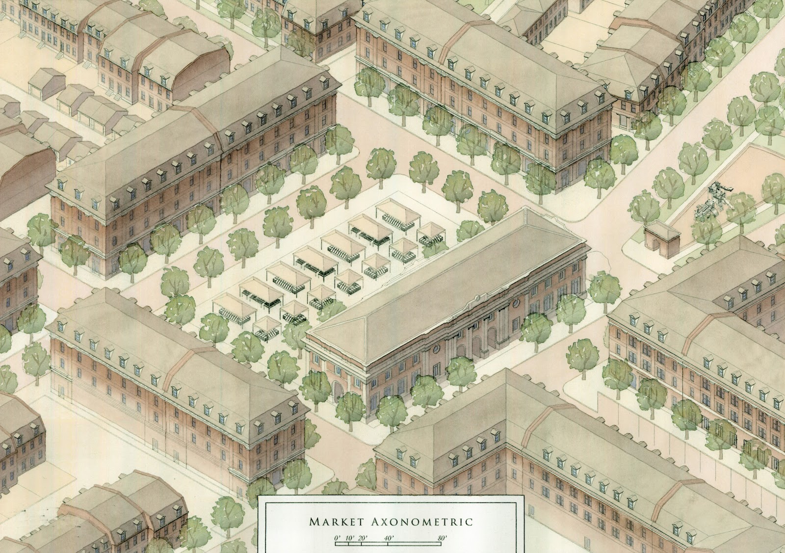
The heart of the development, this brick paved public space is surrounded by mixed-use buildings containing shops, restaurants, and apartments. The space can be used for many types of events, including concerts and festivals.
B. Community Center / Market Hall
This public building contains a ground fl oor Market Hall, which will be the weekday home for an expanded North City Farmer’s Market (Saturdays would continue to be held at Old North St. Louis). The upper floor serves as a Community Center, with exhibits on the history of Pruitt Igoe and the Near North Side, as well as spaces for after school programs and local meetings.
C. Park
A public park provides residents with centralized and defi ned open space for outdoor activities. This park is not specifically dedicated to athletics, as is the park to the South of the site, but is intended for general recreation.
D. Playground
Playgrounds are an essential feature in neighborhoods with children. This one is located in the center of the site, adjacent to the Plaza and Community Garden, so that parents using
these other amenities can visit the playground with their children (Figure 18).
E. Community Garden
The Community Garden gives residents the opportunity to grow their own food and meet their neighbors. Some of the food can be sold at the market, and some can be taken home by gardeners.
F. Constructed Wetland & Pond
A Constructed Wetland and Pond collect storm water, minimizing the strain on the sewer system, and provide residents with a beautiful place to enjoy native plants, birds, and butterflies (Figure 9).
G. Carriage House Park
This small park serves the residents living in Carriage Houses, providing them with dedicated outdoor space, in lieu of yards.
In addition to these new amenities, the three bus lines which run along the site’s perimeter provide a total of seven bus stops directly adjacent to the site. There are also five churches and two schools less than 1/8 mile from the site.
Vernacular St. Louis building types are explored as precedents and emulated in the buildings found in the new master plan. Utilizing local building types helps St. Louis to maintain its architectural identity, helps to encourage craftsmen and builders to learn vernacular building details and typologies, and helps to prevent the stigma which can become attached to affordable housing which is clearly differentiated from the rest of a neighborhood. The predominant exterior building material for the new buildings will be St. Louis Brick, which is prized for its quality (to the point where it has often been stolen from unoccupied buildings). Building types include: the Garage, Carriage House, Single Family Row House, Duplex, Triplex, Corner Store, Mixed-Use Commercial/Residential, Office, and Civic building.
Each type is composed of pieces from a limited kit of parts containing windows, doors, or dormers. By maintaining a kit of parts from which to choose for each individual building within a building type, variety is added while keeping costs low. Nearly every building in the master plan is an attached building type, for four reasons (beyond the fact that many St. Louis buildings, especially in neighborhoods like Soulard, are attached). First, attached buildings conserve energy by sharing heating and cooling loads between party walls instead of expelling conditioned air entirely into the outdoors. Second, attaching naturally keeps the side elevations of most buildings from being exposed. This allows the side elevations to be constructed more economically, permitting more of the construction funds to be used to create higher quality front and rear elevations. Third, attached buildings create the most effective street wall for the containment of space, and can fit on narrow lots, increasing the unit density of a development. Lastly, attached buildings may more easily mask the difference between affordable and market rate units, enabling a smother incorporation of various income levels, which is an important goal of this project.

An overall view of the neighborhood
A closer view of the Market Plaza, Market Hall/Community Center, and Playground
Looking towards the Market Hall/Community Center down James Cool Papa Bell Ave.
The Market Plaza during an outdoor market
The Market Hall/Community Center from the North
The redevelopment of the Pruitt-Igoe site can be a catalyst for rebuilding the North Side in a sensitive manner. Inspired by the beautiful brick neighborhoods found throughout St. Louis, the new design is rooted in the building culture that created the city, and works to create a home for people of various incomes and ages, and an active neighborhood center for cultural and commercial life.